Pollino National Park, the largest national park in Italy, captivates travellers with its rugged, natural beauty. Located on the border between Calabria and Basilicata, this vast protected area covers an impressive 192,565 hectares, making it one of the most interesting natural sites in the entire Mediterranean basin. It offers extraordinarily diverse landscapes – from the mighty peaks of Monte Pollino to picturesque gorges and caves shaped by karst processes and river erosion. Its unique geoheritage, protected as the Pollino UNESCO Global Geopark, represents not only a natural treasure but also an invitation to active outdoor recreation.
Table of Contents
- The Development of Pollino National Park – Conservation and Natural Heritage
- The Significance of Pollino National Park for the Region
- Unique Fauna and Flora of Pollino National Park – Italy's Biodiversity Treasures
- Extraordinary Natural Wealth and Rock Formations in Pollino National Park
- Tourism and Recreation in the Heart of Pollino National Park
- Challenges in Managing Pollino National Park – Conservation and Sustainable Development
The Development of Pollino National Park – Conservation and Natural Heritage
Established at the meeting point of southern Italy's regions, Pollino National Park is an exceptionally important area for protecting unique ecosystems in the Southern Apennines. A key moment was the framework law on protected areas no. 394 of 6 December 1991, and the Parco Nazionale del Pollino was formally established by a decree of the President of the Republic on 15 November 1993. In 1994, administrative structures were organised covering 56 municipalities on both sides of the regional border. The park's headquarters are located in Rotonda, which serves as the central logistical hub for the entire region.
The park's highly varied terrain – particularly the watersheds of major rivers, mountain massifs, and karst forms and canyons shaped by erosion – is essential for preserving local biodiversity. A decisive role is played by the protection of characteristic species such as the Bosnian pine (Pinus heldreichii), and the valuable beech forests associated with the Pollino area. It is precisely such elements – from ancient stands to rugged limestone ridges – that build the exceptional natural value of the entire massif.
| Administrative Parameter | Value / Description |
|---|---|
| Total Area | 192,565 ha |
| Area in Calabria | 103,915 ha |
| Area in Basilicata | 88,650 ha |
| Number of Municipalities | 56 |
| Park Headquarters | Rotonda (PZ) |
The park's development initiatives focus on promoting sustainable tourism, including managing trails such as the Civita trekking route and exploring Bosco Magnano. These efforts aim to reduce the negative impact of visitors on delicate ecosystems through appropriate education and infrastructure. Thanks to these endeavours, Pollino National Park is becoming an important model for nature management in southern Italy, combining environmental protection with the needs of local communities.
The Significance of Pollino National Park for the Region
Pollino National Park plays a strategic role in the local ecosystem as well as in the economy and culture of surrounding communities. As Italy's largest national park, it lies between the spheres of influence of the Tyrrhenian and Ionian Seas, resulting in varied natural conditions across the region. Over the years it has become an important point of reference for nature conservation in southern Italy, protecting unique life forms including the region's icon – the Bosnian pine known as Pino loricato.
Beyond protecting flora and fauna, the park stimulates local tourism, which is of fundamental importance to the regional economy. Hiking trails leading through the highest peaks attract nature-seekers, who in turn support local crafts, accommodation and gastronomy. The Arbëreshë communities, descendants of Albanian migrants settling in southern Italy from the 15th century, are one of the strongest cultural features of the Pollino area, particularly in places such as Civita, Frascineto, San Basile, Lungro and Acquaformosa.
Some of these communities have preserved the Arbëresh language, traditional costumes, ceremonies and the Byzantine-Greek liturgy within the Byzantine rite Catholic Church. For the residents of surrounding villages, the park remains an important source of identity, connecting nature with the history of the borderlands. In the nearby Pollino area there are also important archaeological sites, such as the Grotta del Romito in Papasidero, known for its Palaeolithic remains.
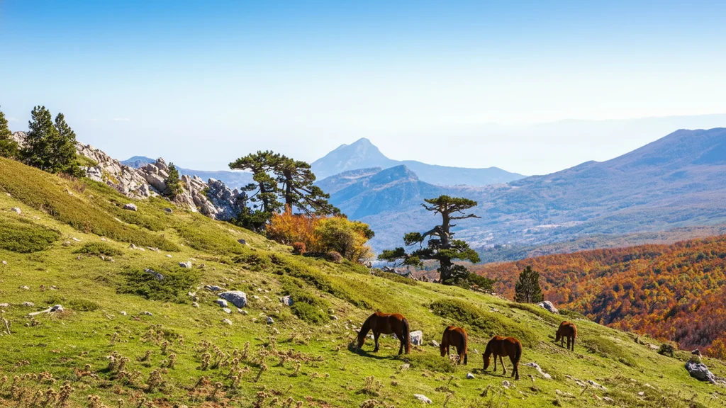
Unique Fauna and Flora of Pollino National Park – Italy's Biodiversity Treasures
Pollino National Park is one of the most important reservoirs of life in Southern Europe, where approximately 1,800–2,000 plant species occur. The altitudinal variation means you can encounter both Mediterranean vegetation and alpine meadows. One of the most remarkable discoveries in recent years is Italus – a Bosnian pine estimated to be at least 1,230 years old, considered one of the oldest scientifically dated trees in Europe.
Botanical Diversity
The park's flora is a mosaic of unique habitats, from deciduous forests in the valleys to alpine meadows on the peaks. The lower areas are dominated by scrub and Mediterranean forests with various oaks, while higher up extensive beech forests and mountain communities appear. Pino loricato, the park's symbol, typically grows above approximately 1,500 m a.s.l., particularly on exposed ridges of Pollino and Serra di Crispo. It is a relict mountain species with characteristic plated, fissured bark, capable of surviving for hundreds of years on limestone and windswept sites.
Wildlife
The fauna of Pollino is very diverse, and among its most recognisable species the Apennine wolf remains prominent. The park is also home to the Eurasian otter, associated with the clean waters of rivers, and birds of prey nesting on limestone cliffs. An important indicator of habitat quality is also the spectacled salamander, found in the moister parts of the forest.
| Species | Ecological Significance |
|---|---|
| Apennine Wolf | Apex predator, symbol of the region's wildness |
| Eurasian Otter | Indicator of the highest river water quality |
| Golden Eagle | Nests on inaccessible limestone cliffs |
| Spectacled Salamander | Italian endemic, bioindicator of habitat quality |
Extraordinary Natural Wealth and Rock Formations in Pollino National Park
The geological history of this area dates back to the Mesozoic era, and the modern landscape is the result of the collision of the African and European tectonic plates. The Pollino massif is built mainly of Mesozoic carbonate rocks – limestones and dolomites – which favour the development of karst phenomena such as caves, sinkholes, springs and canyons. The Pollino area was included in the UNESCO Global Geoparks network in 2015 due to its exceptional geoheritage, clearly visible both on the ridges and in the deeply incised river valleys.
Geological Formations
The rich relief includes numerous caves and caverns that are the result of long-term karst processes and water-modelling of the mountains. Important watercourses associated with the area include the Lao, Raganello, Sinni, Coscile, Esaro and Sarmento. The Gole del Raganello are among the most famous canyons in southern Italy, and the Lao valley has long attracted river sports enthusiasts.
Biodiversity and Flora
In terms of natural wealth, Pollino stands out with approximately 1,800–2,000 plant species. The aforementioned Bosnian pine, Pino loricato, is a living fossil whose silhouettes – often twisted by the wind – give the landscape an almost surreal appearance. The park also protects valuable species associated with humid forests and clean watercourses, including the spectacled salamander.
Watch on YouTube
Tourism and Recreation in the Heart of Pollino National Park
Pollino National Park is a true paradise for hiking enthusiasts, offering the highest peaks in southern Italy. The roof of the region is Serra Dolcedorme, reaching 2,267 m a.s.l., from which on a clear day you can see both seas surrounding the peninsula. The park's orography encompasses five peaks exceeding 2,000 metres, guaranteeing high-mountain experiences for much of the year.
Hiking Trails and Natural Attractions
A popular destination is Monte Pollino (2,248 m a.s.l.), with classic approaches usually starting from Colle dell'Impiso at around 1,570 m a.s.l. Depending on the route, the round trip takes roughly 5–7 hours. Serra di Crispo, known as the Garden of the Gods, has a similar round-trip time from Colle dell'Impiso and is considered a moderately difficult route, offering stands of Pino loricato along the way.
A longer and more demanding option is Serra Dolcedorme, usually planned as a 7–9 hour round trip, with elevation gain exceeding 800–1,000 metres depending on the variant. For a more relaxed day, Piano Ruggio – a popular plateau serving as a starting point for shorter walks and winter snowshoe outings – works well. For adrenaline seekers, the Lao river offers some of Italy's best rafting conditions, but in the case of the Raganello gorges it is essential to check current access rules.
Recreation and Rest
Besides trekking, the park offers mountain biking, birdwatching and winter snowshoeing on the Piano Ruggio plateaus. The refuge network, though varied, requires advance planning – it is worth checking the status of facilities such as Rifugio Fasanelli and Rifugio Biagio Longo. Base towns such as Civita, Morano Calabro and Castrovillari make excellent starting points, and along the way you can easily find local sheep and goat cheeses, dishes with beans and wild herbs, and bread and pastries from the Arbëreshë cuisine.
On the Basilicata side of Pollino, the Fagiolo Bianco di Rotonda with its protected PGI (IGP) designation is particularly well known. Admission to Pollino National Park as a protected area is generally free, while separate charges apply for guide services, rafting, canyoning, private car parks and museum exhibitions on the edges. On many trails there are no gates or ticket offices, which is why in practice the most important resources are tourist information points and local AIGAE guides and park officials.
Challenges in Managing Pollino National Park – Conservation and Sustainable Development
Managing Italy's largest protected area requires balancing nature conservation with tourism development. Heavy tourist presence in places such as the Raganello gorges requires strict regulations to prevent the degradation of unique ecosystems. Park managers must also contend with the risk of fires and droughts, which in the era of climate change threaten Bosnian pine populations.
An additional challenge is cooperation with local communities regarding land use, pastoralism and traditional hunting. This dialogue is essential to preserve cultural heritage such as the culinary and linguistic traditions of the Arbëreshë minority, while enforcing strict environmental protection standards. Pollino's sustainable development rests on promoting so-called slow tourism, encouraging deep engagement with nature without destroying it.
It is worth noting that the Gole del Raganello is a high-risk area during heavy rainfall. After the tragedy of 20 August 2018, when a sudden flash flood caused the death of 10 people, access to parts of the gorge is subject to strict regulations, temporary closures and safety rules. Entry to certain trail sections often requires the use of authorised guides and checking current communications from the municipality of Civita and civil protection services.
Pollino National Park – Frequently Asked Questions
Where is Pollino National Park located?
The park is located on the border between the Calabria and Basilicata regions in southern Italy, covering the provinces of Cosenza, Potenza and Matera.
Why is Pollino unique among Italy's national parks?
It is Italy's largest national park (over 192,000 ha), holds UNESCO Global Geopark status, and protects one of the oldest scientifically dated trees in Europe – the Italus pine.
Which peaks can you climb in Pollino?
The most important summits include Serra Dolcedorme (2,267 m a.s.l.), Monte Pollino (2,248 m a.s.l.) and Serra del Prete (2,181 m a.s.l.).
What is the Bosnian pine and where can you see it?
It is a rare tree species (Pinus heldreichii), the park's symbol, characterised by plated, fissured bark resembling armour. The most characteristic specimens grow on exposed ridges of Pollino and Serra di Crispo, typically above approximately 1,500 m a.s.l.
How should you best plan a visit to Pollino Park?
It is best to arrive by car via the A2 motorway, choose a base in towns such as Castrovillari, Morano Calabro, Civita or Rotonda, and if needed use the services of certified park guides. The most versatile months for trekking are May–June and September–October; in winter the higher areas can have snow and ice, and weather in the massif can change quickly.
Main Attractions of Pollino National Park
Serra Dolcedorme
The park's highest peak (2,267 m a.s.l.). In good weather you can see both the Tyrrhenian and Ionian Seas simultaneously.
Gole del Raganello
A spectacular 13 km canyon carved by the river through limestone. A paradise for canyoning enthusiasts and wildlife lovers.
The Italus Pine
One of the oldest scientifically dated trees in Europe (approx. 1,230 years old). It grows in the Pollino area and is a symbol of the longevity of the local mountain pines.
Civita – Arbëreshë Village
A unique village inhabited by descendants of Albanian refugees, preserving their original culture, language and traditions.
Rafting on the Lao River
Some of the best rafting conditions in Italy. The river flows through pristine lands in the province of Cosenza.
How to Get to Pollino National Park
For the Calabrian side, fly into Lamezia Terme (SUF) – Castrovillari is ~135–145 km (1h 40min–2h) by car. For the Basilicata side, Naples airport (NAP) is closer – Rotonda is ~240–260 km (~3h). Car hire essential for exploring the park.
The A2 Autostrada del Mediterraneo is the main access road. Typical exits for the Calabrian side are Morano Calabro, Castrovillari and Frascineto, with the most convenient bases being Castrovillari, Morano Calabro, Civita and Papasidero; on the Basilicata side, Rotonda and Viggianello among others.
Without a car, access is limited and usually requires a combination of train and regional bus or transfer. In practice, it is best to plan a route via Cosenza, Sibari or Paola and then look for onward connections to your chosen base.
The most common approach is by rail to Sibari, Paola or Cosenza station, then by regional bus or car. This is a less convenient option than driving yourself, but with good planning it allows you to reach the edges of the massif.